
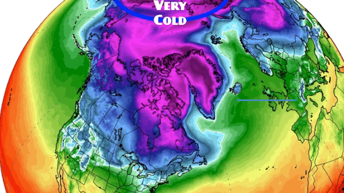

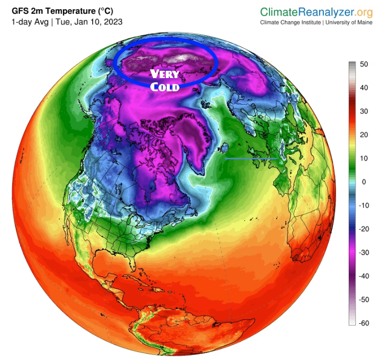
Several weeks after the Christmas Arctic blast, much of the US and Europe have enjoyed record warmth. Recall on Dec. 27, we noted the cold air mass from Siberia that spread across the continental US would dissipate into the new year. So far, this is correct, as three weeks of above-average weather has staved off an energy crisis in the Northern Hemisphere. But just north, in Siberia, temperatures are sinking to near-record lows. And it could only be a matter of time before the giant cold air mass swirling in the North Pole becomes unstable, breaks down, and begins pouring into the US and Europe.
Global warming alarmists who called for an imminent climate disaster last summer are scratching their heads as the rural northern Siberian town of Zhilinda just recorded temperatures of minus-79.8 degrees, according to climatologist Maximiliano Herrera, who tracks extreme temperatures across the globe.
Herrera told The Washington Post that Zhilinda was just a few degrees off from breaking its record low of minus-82.3 degrees. The all-time low for the Northern Hemisphere was set in Russia in 1933 at minus-89.9 degrees.
Earlier this week, Arcfield Weather’s Paul Dorian said winter isn’t over and called for a significant change in North American weather “in about ten days or so.” Like anything, nothing is ever constant, and the warm spell could give way to colder temps later this month or early February.
“Sometimes, exceptionally cold air that builds over Siberia spills into the eastern United States,” WaPo explained, adding:
“Although the eastern United States has had very mild weather since that late December cold blast, there is the potential for a significant pattern change toward the end of January.”
For a polar vortex to flow into the US or Europe, there first needs warming in the Arctic stratosphere that pushes cold air lower. As explained by Michigan Weather Forecast:
This begins with the warming in the Arctic stratosphere which pushes the cold air south (simply put). The GFS, GEFS, ECMWS, and GEM models are displaying similar model runs. This is more of a heads-up than anything else. Do with it as you will, it is my humble opinion that winter in the sense of cold and snow isn’t over yet. We will see if the CPC comes on board with this.
And on Twitter, many folks are posting models predicting winter isn’t over and all that cold air trapped in the Arctic could pour into Europe and the US in the coming weeks.
Up in the mid-upper Polar Stratosphere (20-30km above the Pole), there are signs the currently stronger than normal Polar Vortex will start to weaken/warm by end of Jan/early Feb. Details on this are still not clear yet, but how this pans out will be key for February’s weather! pic.twitter.com/gAJMgxAMHJ
— wxcharts – a MetDesk Company (@wxcharts) January 13, 2023
For those who want a straightforward bottom line – #PolarVortex & tropospheric circulation are predicted to become increasingly coupled & supportive of more widespread #cold & #snow across the Northern Hemisphere in coming weeks but the important details are mostly still unknown. pic.twitter.com/7t7MO9nSPK
— Judah Cohen (@judah47) January 13, 2023
GFS continues to provide interest alongside yesterday’s EC update, with regards the #spv stratospheric polar vortex
Marked warming, hints of wave2 split & W wind speed reduction from 120mph+ to 30 or less..some output reversing to Ely..ie a major #ssw
Very early days still..👀 pic.twitter.com/vnr6M517H9
— Marco Petagna (@Petagna) January 13, 2023
#natgas
It is impressive how fast the stratospheric vortex implodes by Jan29 (left) as warm air swallows the remains of a once mighty vortex (Jan9, right). This will reduce centrifugal forces and zonal winds, which will open the gates for polar air to flood continents. pic.twitter.com/mRRIAZHI7b— Heinrich Leopold (@LeopoldHeinrich) January 13, 2023
12z GFS Op starting to show a #PolarVortex split at 10hPa @PvForecast @judah47 Things are heating up! pic.twitter.com/ZzcuAGsQT7
— Mark Margavage (@MeteoMark) January 13, 2023
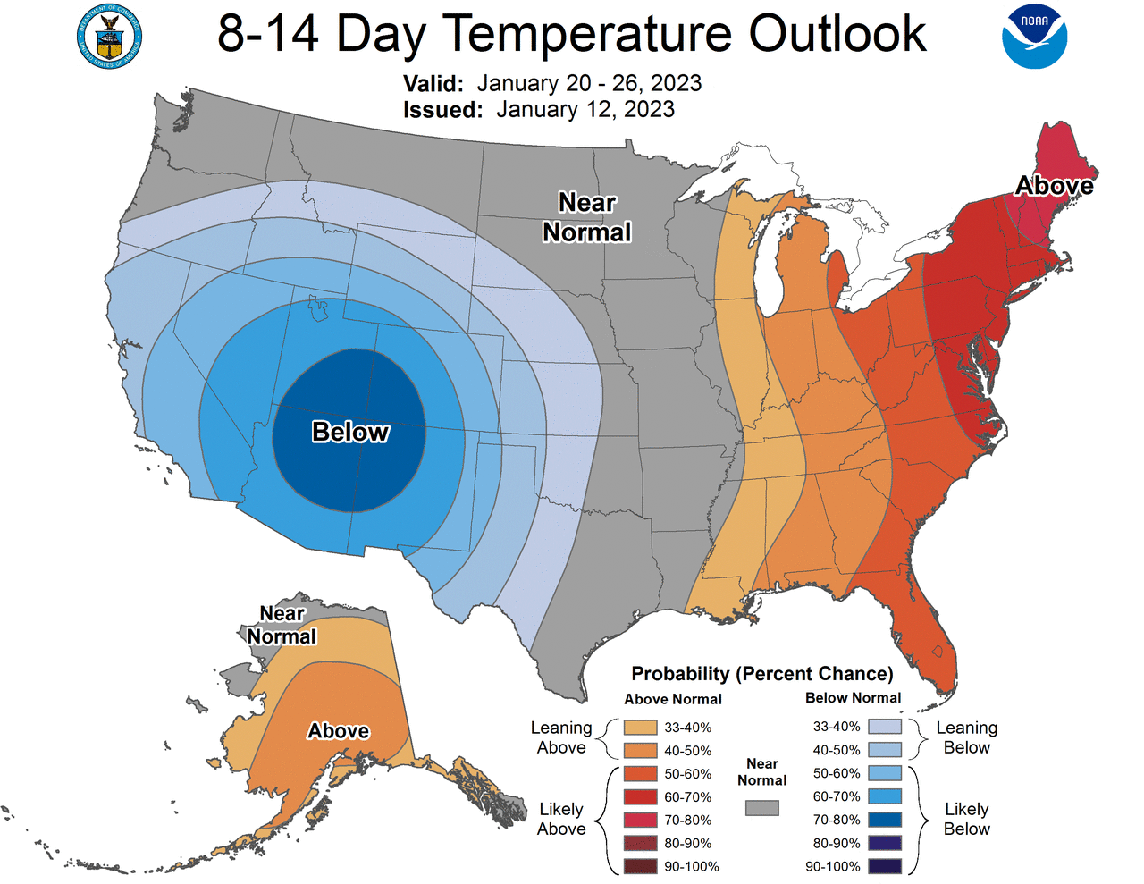
And maybe there’s some validity in the models above as the Climate Prediction Center’s 8-14 day temperature outlook has increasingly shown over the last week of colder weather slated for the end of the month.
So if the models are correct. Winter was just delayed.
by Tyler Durden

Join: 👉 https://t.me/acnewspatriots
The opinions expressed by contributors and/or content partners are their own and do not necessarily reflect the views of AC.NEWS
Disclaimer: This article may contain statements that reflect the opinion of the author. The contents of this article are of sole responsibility of the author(s). AC.News will not be responsible for any inaccurate or incorrect statement in this article www.ac.news websites contain copyrighted material the use of which has not always been specifically authorized by the copyright owner. We are making such material available to our readers under the provisions of “fair use” in an effort to advance a better understanding of political, health, economic and social issues. The material on this site is distributed without profit to those who have expressed a prior interest in receiving it for research and educational purposes. If you wish to use copyrighted material for purposes other than “fair use” you must request permission from the copyright owner. Reprinting this article: Non-commercial use OK. If you wish to use copyrighted material for purposes other than “fair use” you must request permission from the copyright owner.
Disclaimer: The information and opinions shared are for informational purposes only including, but not limited to, text, graphics, images and other material are not intended as medical advice or instruction. Nothing mentioned is intended to be a substitute for professional medical advice, diagnosis or treatment.


![Tucker Carlson Released an ALARMING Message … [Published Yesterday]](https://ac.news/wp-content/uploads/2024/04/download-3-120x86.jpg)


Discussion about this post