
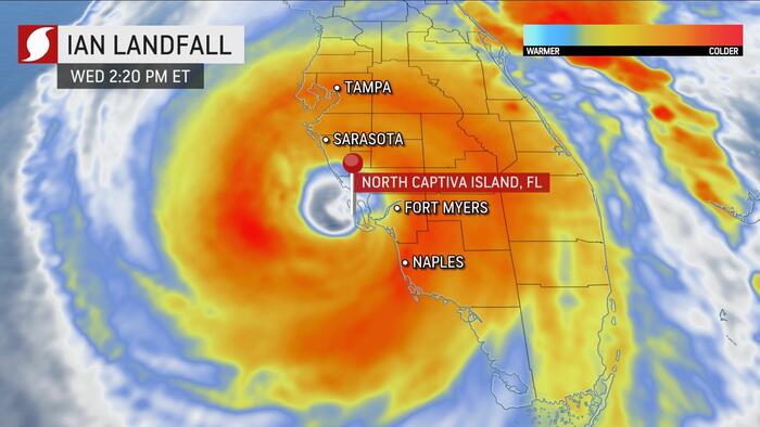

Update (1510ET):
Accuweather has declared Hurricane Ian made landfall around 1420 ET on North Captiva Island, a barrier island just west of Fort Myers, Florida. The storm came ashore with maximum sustained winds of 155 mph.

This is absolutely shocking…
⚠️ Horrific scene in Matlacha/Pine Island, Florida where storm surge and strong Cat 4 winds from #HurricaneIan has battered the small island community. pic.twitter.com/cdmKQLjYd5
— Alejandro Galiano ❁ (@havanahistory) September 28, 2022
Naples. Houses are moving pic.twitter.com/nFVY9oP1y4
— reallyryanbush (new acct) (@reallyryanbush) September 28, 2022
Storm surge outside of my moms house on Fort Myers Beach.
I’m so sick. pic.twitter.com/12ujJqmacH
— Beth #GetCaroleHome (@itsbethbooker) September 28, 2022
Homes float away, several others damaged, as #Ian hammers Fort Myers Beach, #Florida. Over 5,24,000 homes and businesses without power in Florida#FLwx #HurricaneIan #Hurricane #FortMyers #Huracan #Cubano #LeeCounty #Viral #Climate #Rain #Storm #Tropicswx
VC: Loni Architects pic.twitter.com/NFaJKWrkEo
— Earth42morrow (@Earth42morrow) September 28, 2022
WATCH: A Lee’s Summit couple on vacation on an island off Fort Myers, Florida, is stranded there as #HurricaneIan ravages the state with catastrophic storm surges.
Story: https://t.co/CvTQQHxLqi pic.twitter.com/uYuLKKIPod
— KCTV5 News (@KCTV5) September 28, 2022
Storm surge in Fort Myers looks like a yacht has broken free and is roaming the streets. #hurricanian #ianhurricane #Ian pic.twitter.com/Wfbn9MFB7p
— Jayden X (@nojaydenx) September 28, 2022
Sharknado?
The storm surge is so powerful from #HurricaneIan that it has brought a shark into the city streets of Fort Myers.
🎥@BradHabuda pic.twitter.com/RHY0kK5RHR
— Colin McCarthy (@US_Stormwatch) September 28, 2022
Update (1247ET):
The National Weather Service reports powerful Hurricane Ian is nearing landfall on the southwest coast of Florida. NWS expects “catastrophic storm surge and wind damage” will occur across Charlotte County, just north of Fort Myers.
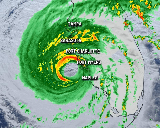
Recent readings showed Ian had sustained winds of 155 mph, only 2 mph shy of a Category 5 storm. As of 1144 ET, the storm’s “outer eyewall” was about 20 miles from land, according to meteorologist Jason Boyer.
Hurricane #Ian is slowing down as it nears landfall in SW FL.
.
The outer eye wall is ~20 miles from mainland FL.
.
The storm remains intense, nearing category 5 (157+mph) strength. #flwx pic.twitter.com/TYECXi5JcP— Jason Boyer (@JasonBoyerWLOS) September 28, 2022
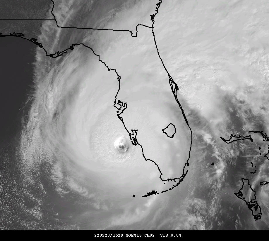
NWS provided satellite footage of Ian encompassing nearly the whole state of Florida.
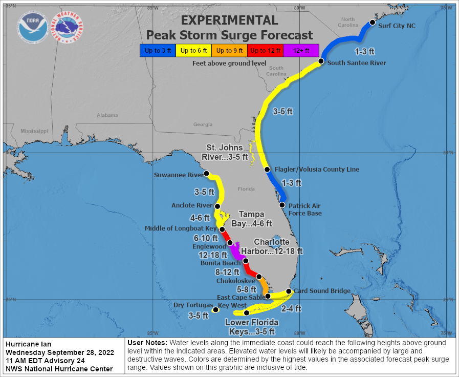
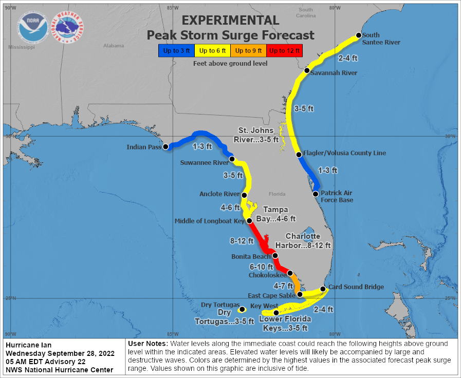
NWS shows a 12-18 feet storm surge forecasted for Charlotte County.
Horrifying videos have been posted on social media showing Ian’s wrath ahead of landfall expected this afternoon.
Incredible video from Sanibel Island in Florida as Hurricane Ian moves in around midday Wednesday. The worst is yet to come unfortunately. #flwx #HurricaneIan pic.twitter.com/8rq2XAwoaY
— Joliet Weather Center 🌤 (@JolietWeather) September 28, 2022
LAST MOMENTS OF SANIBEL ISLAND SURGE PACK: Unfortunately, our @cyclonePORT was taken by the extreme winds and storm surge just moments ago. Here are the last moments on camera. @ryanhallyall pic.twitter.com/02a8hl4x2L
— RadarOmega (@RadarOmega) September 28, 2022
Lanai sent airborne in Cape Coral, Florida by Hurricane #Ian’s winds.
Video sent in by a WINK viewer pic.twitter.com/TrbmocjL9A
— Nash Rhodes (@NashWX) September 28, 2022
Sparks and flames explode from downed power lines in Naples, Florida, ahead of Hurricane Ian.
LIVE UPDATES: https://t.co/pprirarnV5 pic.twitter.com/xs6iAmeVKE
— ABC News (@ABC) September 28, 2022
Currently in Fort Myers, Florida. Video by Loni Architects #flwx #Ian #hurricane pic.twitter.com/8nfncFlG9G
— Kaitlin Wright (@wxkaitlin) September 28, 2022
From NBC2's camera, there is a significant amount of storm surge inundation at Naples Grande, FL.#flwx #weather #Ian pic.twitter.com/mwhNt4O6Iy
— Weather Track US (@weathertrackus) September 28, 2022
‼️Live video on @weatherchannel shows dangerous storm surge from #Hurricane Ian making landfall in Fort Myers, #Florida.
Even worse, much severe storm surge is yet to come.#Ian #FLwx #HurricaneIan
🎥@CollinGrossWx pic.twitter.com/Zjd1C19ad5— Dena Grayson, MD, PhD (@DrDenaGrayson) September 28, 2022
Dangerous and damaging storm Surge in Naples, FL from Naples Fire Dept. #HurricaneIan #flwx pic.twitter.com/ctpi0GcnQe
— Mike Clay (@Mike_Clay) September 28, 2022
Fort Myers, Florida #hurricaineIan #USA pic.twitter.com/XM1vU42IRP #BreakingNews
— Javi (@Javiergg9885) September 28, 2022
* * *
Update (0739ET):
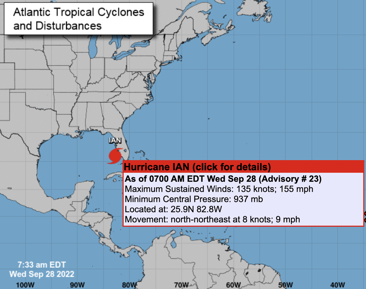
Hurricane Ian continues to strengthen ahead of landfall. As of 0733 ET, the National Hurricane Center said Ian’s sustained maximum winds were 155 mph, just 2 mph shy of a Cat. 5 storm.
* * *
Hurricane Ian strengthened into a powerful Category 4 storm expected to make landfall on Florida’s southwest coast today and then traverse central Florida and emerge in the Atlantic by Thursday.
At 0500 ET, the National Hurricane Center said Ian sustained maximum winds of 140 mph and gusts up to 165 mph. The storm’s center was about 75 miles west-southwest of Naples and 105 miles south-southwest of Punta Gorda, moving north-northeast at 10 mph.
“Ian is forecast to approach the west coast of Florida as an extremely dangerous major hurricane, weakening is expected after landfall.
“On the forecast track, the center of Ian is expected to approach the west coast of Florida within the hurricane warning area this morning, and move onshore later today. The center of Ian is forecast to move over central Florida tonight and Thursday morning and emerge over the western Atlantic by late Thursday,” NHC senior hurricane specialist Daniel Brown told Orlando Sentinel.
Ian’s path has shifted south of Tampa Bay, and landfall is now expected between Fort Myers and Sarasota on Wednesday morning or early afternoon before moving across the central part of the state.

NHC warned a “life-threatening storm surge is expected along the Florida west coast and the Lower Florida Keys,” with “devastating wind damage” expected near Ian’s center.
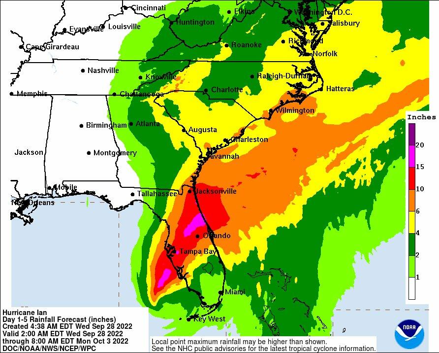
“Catastrophic flooding is expected across portions of central Florida with considerable flooding in southern Florida, northern Florida, southeastern Georgia and coastal South Carolina,” the weather agency continued.
“It’s going to be historic,” National Weather Service Melbourne meteorologist Kole Fehling in Melbourne, referring to the storm’s landfall impacts.
Fehling said Central Florida could be swamped with 15 to 20 inches of rainfall, with some areas receiving upwards of 24 inches.
“The normal value for the amount of rainfall over the entire year is about 52 inches,” he said. “So if we were to see those higher- end totals, we could be experiencing half of our total annual rainfall in a very short period of time.”
On Tuesday night, Florida Governor Ron DeSantis told residents:
“You need to evacuate now. You’re going to start feeling major impacts of this storm relatively soon.”
Millions of Floridians are under evacuation orders or advisories as DeSantis activated the National Guard earlier this week before the storm’s arrival.
There are notable economic impacts due to adverse weather conditions in the region. On Tuesday evening, US energy companies idled 190,000 barrels of daily crude production, some 11% of US Gulf of Mexico output.
Bloomberg pointed out that the “nation’s production of phosphate fertilizer” is in the storm’s path.
Chuck Watson, a disaster modeler with Enki Research, said Mosaic’s New Wales plant is “right in the middle of the damage swath,” adding the facility “could be out for weeks.”
Bloomberg said Ian could cause $45 billion in damage, which would make it one of the most costly storms in the country’s history.
By late Tuesday, over 2,000 flights to and from Florida were canceled. Flight delays and cancelations could spill over to the rest of the country.
by Tyler Durden

Join: 👉 https://t.me/acnewspatriots
The opinions expressed by contributors and/or content partners are their own and do not necessarily reflect the views of AC.NEWS
Disclaimer: This article may contain statements that reflect the opinion of the author. The contents of this article are of sole responsibility of the author(s). AC.News will not be responsible for any inaccurate or incorrect statement in this article www.ac.news websites contain copyrighted material the use of which has not always been specifically authorized by the copyright owner. We are making such material available to our readers under the provisions of “fair use” in an effort to advance a better understanding of political, health, economic and social issues. The material on this site is distributed without profit to those who have expressed a prior interest in receiving it for research and educational purposes. If you wish to use copyrighted material for purposes other than “fair use” you must request permission from the copyright owner. Reprinting this article: Non-commercial use OK. If you wish to use copyrighted material for purposes other than “fair use” you must request permission from the copyright owner.
Disclaimer: The information and opinions shared are for informational purposes only including, but not limited to, text, graphics, images and other material are not intended as medical advice or instruction. Nothing mentioned is intended to be a substitute for professional medical advice, diagnosis or treatment.


![Tucker Carlson Released an ALARMING Message … [Published Yesterday]](https://ac.news/wp-content/uploads/2024/04/download-3-120x86.jpg)


![BENJAMIN FULFORD GEOPOLITICAL UPDATE 4⧸1⧸24…AUDIO READING [mirrored]](https://ac.news/wp-content/uploads/2024/04/download-16-120x86.jpeg)


Discussion about this post